 GPS and GNSS are satellite-based systems globally used to determine positioning, navigation and timing (PNT). GNSS is a broader term that encapsulates different types of global and regional satellite-based navigation systems. GPS is one of the GNSS systems developed by the US.
Apart from GPS, GNSS includes three more global satellite-based navigation systems and two regional satellite-based navigation systems. We will discuss each of them in the content below and try to identify every possible difference between GPS and GNSS.
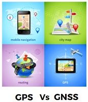
Content: GPS Vs GNSS
Comparison Chart
| Basis of Comparison | GPS | GNSS |
|---|---|---|
| Full Form | Global Positioning System | Global Navigation Satellite System |
| Primary Use | Offers (PNT) positioning, navigation and timing to civilians and defence forces around the world to the receiving equipment. | Offers positioning, navigation and timing for various applications used for navigation, agriculture, surveying and disaster management. |
| Coverage | GPS provides global coverage. | Depending on the system, GNSS provides global or regional coverage. |
| Accuracy | Offers accuracy up to 4.9 m. | Accuracy varies from system to system and usually ranges between 5 to 15 meters. |
| Satellite Constellation | As of now, there are 31 satellites in GPS systems. | The number varies from system to system; in general, the number of satellites in GNSS ranges from 24 to 35. |
| Examples | GPS itself is one of the GNSS. | GPS (US), GLONASS (Russia), Galileo (Europe), BeiDou (China), NavIC (India), QZSS (Japan) |
What is GPS?
GPS, i.e., Global Positioning System, originally known as Navstar GPS. Here Navstar means navigation satellite time and range. GPS was the first satellite-based navigation system that covered the entire world.
As of now, GPS is comprised of three segments –
- The constellation of 31 GPS satellites orbiting in 6 MEO planes that broadcast navigation signals.
- Network of ground stations.
- Satellite control stations monitor and control the satellites in the system.
The orbit height of the satellite is approximately 11 miles and accurately provides information on position, navigation and time up to 4.9 m all around the world, irrespective of the weather condition.
The defence force of the US government, i.e., DRDO (Department of Defense), operates and maintains the GPS system. The National Space-Based Executive Committee (EXCOM) guides DoD on GPS-related matters.
What is GNSS?
GNSS, i.e., a Global Navigation Satellite System, is a global term encompassing all satellite-based navigation systems used for various purposes, such as determining location, time, and elevation. Every GNSS system in space has a different constellation of satellites, and they even belong to different countries and unions.
GNSS includes both global navigation satellite-based systems and regional navigation satellite-based systems. In all, there are four global GNSS and two regional GNSS, as discussed below –
- GPS (US)
- GLONASS (Russia)
- Galileo (EU)
- BeiDou (China)
The two regional GNSS (RNSS) systems are i.e.
- QZSS (Japan)
- IRNSS or NavIC (India)
Performance of GNSS
The performance of any GNSS system totally depends on the parameters discussed below:
- Accuracy: how accurate the GNSS system provides information about real positions, speed and time.
- Integrity: how much the user can trust the data provided by the system and the system’s ability to warn the user if the system is not functioning correctly.
- Continuity: how long a system can work efficiently without any interruption.
- Availability: how long a system can fulfil the above accuracy, integrity and continuity criteria.
Structure of GNSS
A GNSS system is more than a constellation of satellites. These constellations of satellite broadcast their signal to the control stations and also to the user segments. There are three segments of GNNS –
- Space Segment
- Control Segments
- User segments
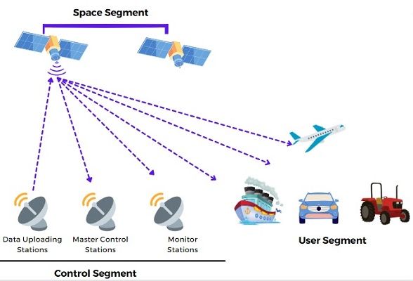 Space Segment – It includes a constellation of satellites orbiting between 20,000 to 37,000 above Earth. The space segment includes four global constellations in orbit GPS, GLONASS, Galileo and BeiDou and two regional constellations, QZSS and IRNSS. Broadcasting the signals of each satellite provides information about – which satellite has transmitted the signals, what its time, on which orbits it is orbiting, status or condition of the satellite.
Control Segment – It includes the network of master control stations, monitoring stations and data uploading stations. These stations are meant for operating, controlling and maintaining the satellites in the constellation.
User Segment – It includes devices and equipment that receives the satellite signals and generate the information related to the position based on the time and orbital location of 4 – 8 satellite.
Key Differences Between GPS and GNSS
- GPS is an acronym for satellite-based navigation system by the United States government Global Positioning System. On the other hand, the GNSS is an acronym for Global Navigation Satellite System.
- GPS offers civilians and defence forces global positioning, navigation and timing services. On the other hand, GNSS offers services such as positioning, navigation and timing for various applications used for navigation, agriculture, surveying and disaster management.
- GPS precisely provides global coverage, which means it will provide information on position, navigation and timing anywhere in the world, in all weather conditions. However, GNSS provides these services globally or regionally, depending on the system in use.
- GPS system provides accurate information up to 4.9 m whereas, depending on the GNSS system used, the accuracy ranges from 5 to 15 m.
- The satellite constellation of the GPS system includes 31 satellites in 6 orbits. However, the satellite constellation of each GNSS varies from system to system.
- Examples of GNSS include GPS (US), GLONASS (Russia), Galileo (Europe), BeiDou (China), NavIC (India), and QZSS (Japan). So, GPS itself is an example of a GNSS system.
Conclusion
So, here we conclude that GPS is one of the GNSS systems, which is a satellite-based navigation system used for determining the information related to positioning, navigation and time. GNSS include systems where some are globally operational, and some are regionally operational. Our GPS system is globally operational.
Leave a Reply